Sunday, October 31, 2010

10/30/2010 ABERDEEN AND THE ARCHITECTURAL DRIVING TOUR

TOTAL MILES TRAVELED TODAY: 0 NM
TOTAL LOCKS:    0

Talk about “frost on the pumpkins”!! When I peeked out the windows this morning I found the fog dragging across the water and Dan found ICE on the top deck. Yes ice! Yikes!!


THE FOG CLOAKS OUR LITTLE COVE 

AND THE NEXT INSTANT---IT SLOWLY BEGINS TO LIFT

We chatted with David and Mary of Ganymede before they took off for Columbus then we took the courtesy car into the old town of Aberdeen. We made a stop at the local auto parts for some tubing for the generator then stopped at the town’s visitor’s center for some local info and a map of the architectural tour.

YEP, THIS MUST BE THE WAY
 Aberdeen was founded in 1837 by Robert Gordon and named for his beloved Aberdeen, Scotland. The proximity to the Tombigbee River was instrumental in the prosperity of the town. The area’s cotton crop could be shipped fast and cheaply to ports along the coast as well as to locations in the northeast. Due to the continued positive economic influence, Aberdeen is host to impressive examples of almost very period and style of Southern Architecture. From the columned Antebellum to the gingerbread Victorians to the turn-of-the–century neoclassical styling and, finally, to the bungalows that I love so much, they are all represented here. Unfortunately, now the community is facing difficulty in maintaining the integrity of these magnificent examples of the past. Here, like many other places, times are hard and it is an expensive proposition to support these old buildings. Here are a few examples of what we saw.


HOLIDAY HAVEN
THIS BEAUTIFUL 1850 GREEK REVIVAL MANSION
WITH DORIC COLUMNS


EVERGREEN WAS ONE OF MY FAVORITES
THIS 1848 HOME WAS ORIGINALLY BUILT IN THE
GREEK REVIVAL STYLE BUT WAS RENOVATED IN
1910 WITH CRAFTSMAN AND BUNGALOW INFLUENCE
THE ADAM FRENCH HOUSE WAS RESTORED IN 2007
AFTER A DEVASTATING FIRE.  NOTE THE LION GUARDING
THE ENTRY AND THE SLENDER IONIC COLUMNS

A PERFECT EXAMPLE OF A GOTHIC STYLE BARN


MY OTHER FAVORITE, WATKIN HILL, STARTED OUT AS
QUEEN ANNE STYLE BUT RENOVATED IN1924 IN THE
SERENE PRAIRIE STYLE

After finishing our driving tour we headed back to Hot Toddy’s street-corner BBQ and grabbed some take-home pork BBQ and ribs. I got to tell you, they were mighty good!


CAN YOU SAY BBQ???

HOT TODDY, AS GOOD AS IT GETS!

Returning to the marina we pulled off to get a preview of our next lock, the Aberdeen Lock, just in time to watch Ganymede finish the lock down and exit. We also found this old, abandoned train station on the river’s banks and old road bridge leading to nowhere.


GANEMEDE JUST LOCKED DOWN THE ABERDEEN LOCK

YOU THINK THERE WAS MAYBE A LITTLE WIND INVOLVED
WITH THE DESTRUCTION ON THE ROOF OF THIS OLD STATION?
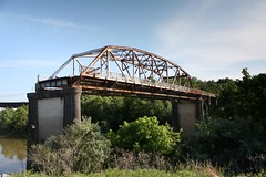

Old US Hwy 45 BridgeImage by cmh2315fl via Flickr
ANOTHER BRIDGE TO NOWHERE
THE OLD HIGHWAY 45 BRIDGE THAT ENDS RIGHT AT THE CHANNEL
Dan worked hard at insulating the mechanical room that houses our noisy generator (aka: the basement). He did some research and came upon a solution that seems to at least reduce the noise to a lesser rumble.


QUEST, HAPPILY DOCKED

As we were heading out for an afternoon walk, Sleeping Bear tied up for the night and we were waylaid a bit with chatting. Once we did get to our walk, Dan found this rather decrepit little barge and, of course, he had to climb aboard and check it out. He just wouldn’t be Dan if he didn’t! We wandered among homes and little branches of the river, thinking what a nice winter home this would be for a boat. As the sun slipped behind the trees we wandered back to our snug home on the water.


DAN EXPLORING THE OLD BARGE
NOTE THE MAN SIZED CLEAT NEAR THE LEFT CORNER

MIRROR IMAGES REFLECTED ON THE GLASS LIKE WATER

AND THE SUN BIDS US GOOD NIGHT UNTIL TOMORROW


Enhanced by Zemanta

Saturday, October 30, 2010

10/29/2010 TRANSITING THE CANAL SECTION OF THE TENN-TOM WATERWAY

ANCHORAGE ABOVE WHITTEN DAM IN BAY SPRINGS LAKE TO ABERDEEN MARINA  AT MM 358.6

TOTAL MILES TRAVELED TODAY:   43 NM

LOCKS TODAY:  6 LOCKS

JAMIE L. WHITTEN LOCK                                MM 412         84’  LIFT

G.V. SONNY MONTGOMERY LOCK              MM 406         30’

JOHN RANKIN LOCK                                      MM 398         30’

FULTON LOCK                                                 MM 391         35’

GLOVER WILKINS LOCK                               MM 376         25’

AMORY LOCK                                                 MM 371         30’


Brrrrr, it was chilly this morning! Sure glad I’m headed south!

We pulled out of our nice little anchorage and right into the first lock of the day, the Whitten Lock. We locked down with the beautiful Summer Song. We have now entered into the second section of the Tenn-Tom, the Canal Section. This 46 mile passage is also known as the Chain of Lakes and, as you can see from the mileage chart above, we pretty much went out of one lock, traveled just a few miles then entered another. The lock masters knew we were coming and kept us moving. Thanks guys.


PRETTY SUMMER SONG

The Jamie L. Whitten Lock had a whopping lift of 84’, the fourth highest in the nation. The Sonny Montgomery and John Rankin were both named after U.S. Representatives from Mississippi, Rankin having been one of the earliest supporters of the Tenn-Tom Waterway. The lake formed by the Fulton Dam, at 1643 acres, is the largest in the Chain of Lakes. Here we caught up to two other boats, the trawler Thomas B along with a sailboat, and locked down together.


Aerial view of the Jamie Whitten Lock and Dam,...Image via Wikipedia
 Aerial view of the John Rankin Lock and Dam on...Image via Wikipedia
JAMIE L. WHITTEN
LOCK AND DAM


                                                                     JOHN RANKIN
                                                                    LOCK AND DAM


About halfway between the Fulton and Wilkins locks we came upon a working dredge that we had to creep by, hugging close to the dredge. Summer Song had wandered a little closer to the banks and snagged a cable. Thankfully he had it idling out of gear and just snagged his stabilizer on their anchor cable. They had him off and running before we reached the site. You really have to communicate with those knowledgeable operators and follow their instructions to the “T”. Within 2 miles we were again slowing way down when a tow taking on fuel requested our cooperation in keeping the water smooth. He was tucked right up to the shore where a fuel truck was pumping directly into his tanks. Who’d a thunk it?


DREDGING THE CHANNEL

TOW TAKING FUEL

The Glover Wilkins Lock was the shortest of the day, only a 25’ lift. The last lock in this Canal Section, the Amory Lock, formed the lake that was the final construction site on the Tenn-Tom.


Aerial view of Glover Wilkins Lock and Dam on ...Image via Wikipedia


GROVER WILKINS LOCK AND DAM


 Amory LockImage via Wikipedia


                                                        AMORY LOCK AND DAM


We’ve began to see more and more birds. Geese were beginning to gather and scads of these cute little black guys with their contrasting white beaks. I think they are Coots. We are still seeing the heron, both the Blue and Great Whites. We were also fortunate to see a spectacular Bald Eagle soaring over the waters this afternoon. Unfortunately, I was too engrossed to have a photo to share with you. The crows were out in full force today. I think they are preparing for their role in the upcoming Halloween night.


GEESE AT THE COLORFUL SHORE

CUTE COOT WITH THEIR WHITE BEAKS


GREAT WHITE HERON

Talk about Halloween, as we wended our way through the marked channel that would lead to our night’s destination at Aberdeen Marina, I felt like I was being let into an spooky Halloween movie set. Twisting and turning among the trees growing out of the water, crows beckoning us to enter, thankfully it was still daylight!!! We did make it in safely and tied up to find no ghouls, ghosts or goblins. Maybe another night.


EERIE ENTRANCE


What we did find here was wooded lands across the waters from our dock and a convenience-like store that served as the marina headquarters.  They pumped auto gas from the front and serviced the boaters with docks and fuel from the back side.  Dan was in heaven when he found fried chicken livers as well as the pickled bologna that Ed and Connie (Sea Estate) had introduced to us.  Needless to say, we had these for our pre-dinner appetizers.  Yum!!


SUNSET OVER QUEST AND GANYMEDEBOW TO BOW


Enhanced by Zemanta

Friday, October 29, 2010

10/28/2010 ENTERING THE TENNESSEE-TOMBIGBEE WATERWAY

ANCHORAGE BY NATCHEZ TRACE PKWY BRIDGE TO ANCHORAGE JUST ABOVE WHITTEN LOCK AND DAM

THURSDAY


TOTAL MILES TRAVELED TODAY: 47 NM

HAPPY BIRTHDAY MIKE QUERREY!! WOO, THE BIG 50!

Our anchor held fast and we had a blissfully calm and quiet night, free of tows and threatening weather fronts. After taking time to appreciate the rising sun’s promise of another day, we pulled up the anchor and were passing under the Natchez Trace Highway Bridge by 7:30.


THE SUNRISE HOLDS THE PROMISE  OF A               NATCHEZ TRACE  HIGHWAY BRIDGE
NEW DAY

The 450 mile long Natchez Trace Highway has a rich history. It follows the route of the historic Natchez Trace that began as an Indian trail and was later used by traders, missionaries and soldiers to connect from Natchez, MS to Jackson MS then on to Nashville, TN. In the late 1700s, flatboats delivered their wares down the Mississippi, were sold for the lumber then the operators would use the trail for their long journey back to their frontier homes. The Trace Highway follows this path and, in places, glimpses of the original rutted trail can still be seen.


By 10:00 we had made our passage from the Tennessee River, through Yellow Creek and were entering the relatively straight, man-made Divide Cut canal section of the Tennessee-Tombigbee Waterway (aka: Tenn-Tom). Contractor labored almost 8 years removing 150,000,000 cu. yards of earth to create this 27 mile long, 280’ wide and 12’ deep canal through which we now wandered.


THE DIVIDE CUT


Detailed map of the Divide Cut on the Tennesse...Image via Wikipedia


Construction on the Tenn-Tom began in 1972 and the waterway opened for commerce in January of 1985. This massive project took over 12 years, cost $2 billion, is 5 times longer and has a total lift 3.5 times greater than the Panama Canal. 307,000,000 cubic yards of earth were removed, 2.2 million cubic yards of concrete poured and 33,000 tons of steel were used. It is one of only two man-made projects that can be identified from space. That’s some undertaking!

Map of the Tennessee-Tombigbee WaterwayImage via Wikipedia 


The canal opens into lovely Bay Springs Lake which spans 6,700 acres with 133 miles of shoreline. We crossed the lake then pulled into the last cove before the Jamie Whitten Lock and Dam and dropped anchor for the day. It was an early day for us, anchoring by 1:30 and having traveled only 47 NM. There was no cell service for research and the blog posting but I worked on the composition then did applied some oil to the wood in the pilot house while Dan began the dastardly chore of sanding and varnishing the outside wood railings.


OUR SAFE LITTLE ANCHORAGE

DAN APPLYING VARNISH

JUDY OILING INSIDE WOOD


When our chores were done we dropped the dingy and putted over to the Bay Springs Visitors Center where we brushed up on our local history, chatted with the US Army Corps’ engineers, wandered the trail to an old dogtrot cabin, ogled the mighty dam then motored back to the Quest in our little dink. I told Dan that it was kind of like motoring around in a little convertible sports car.


BAY SPRINGS LAKE VISITORS CENTER


TENN-TOM DIVIDE CUT CENTER

DOGTROT CABIN


I WISH, I  WISH FOR WATER??


THE DAMN DAM CRANE
Enhanced by Zemanta

Thursday, October 28, 2010

10/27/2010 DITTO LANDING TO KOGER ISL/NATCHEZ TRACE BRIDGE

WEDNESDAY

TOTAL MILES TRAVELED: 82 NM

WAHOO! TODAY WE CELEBRATED OUR 26 ANNIVERSARY.

We were abruptly jarred awake this morning at 6:10 by the shrill alarm emitting from the marina’s boat storage facility. Good grief, enough with the sounds already!! We think it turned out to be a fire sprinkler low pressure alarm, nothing that excited anyone too much though.

Our early start got Dan to Enterprise when they opened at 7:30 and we were throwing off ropes in the rain by 8:30. It was wet and dreary but the “weather” was going on past us and we were headed towards sunny skies. As we pulled out of Ditto we saw some of the damage brought about by the forceful winds. This lovely willow had lost a huge branch and looked rather embarrassed at the loss.

"WEEPING" WILLOW


We enjoyed seeing the beautiful bluffs as we passed them by. Every once in a while we will get a glimpse of some really red dirt, reminiscent of that you see in Oklahoma or on Kauai.


ROCKY BLUFFS

RED DIRT COUNTRY

Once again we approached the railroad bridge at Decatur and had to wait for the long freight train to finish passing over so the bridge tender could raise his mighty bridge for us.


DELIVERING WARES TO OUR WORLD

We spent the morning just cruising along as the sun began to peek out and greet us. We met only one tow and were passed by a pleasure craft that was motoring faster than we. Now I’m reading and Dan is checking out the view when we sort of bog down and I hear yet another funny (OK, not so funny!) sound. It appears that we were scraping along the muddy bottom, having ventured a little out of the navigational channel. No foul, no harm and back on course we continued on our merry way.

Around 1:30 we were approaching the Wheeler Lock and Dam. The lock master invited us to come on over and got us in after opening the gates. This is the lock we had to wait out the fog before locking up on 10/17. No fog for us now, just bright sunshine and blue skies above us.


DAN'S "AT THE READY"

We made a bee line to Wilson Lock and Dam, 15 miles on farther, and were done with our locking down by 4:00. We jammed down the 95’ drop, almost like a carnival ride.

This old pedestrian-only bridge was once the  sole way across the river. The original bridge opened in 1939 as a toll bridge. Trains used the upper while wagons, pedestrians and livestock traveled across on the lower deck. It was rebuilt in 1854 after being destroyed by a tornado and could then accommodate the steam-powered trains. In 1862 it again sustained severe damage when those Confederate troops set it afire in an attempt to halt the advancing Union soldiers. After undergoing several more rebuilds, in 1993 the section over the navigation channel was removed but concerned citizens banded together to keep and restore the remaining section into the current pedestrian walkway.


RESTORED TRAIN BRIDGE

PEDESTRIANS ONLY

We continued on to an open anchorage between little Kogers Island and the Natchez Trace Parkway Bridge where we dropped the hook as the sun gave its last gasp of the day.


GOOD NIGHT ALL

OK, ONE LAST BIT OF FANFARE


Enhanced by Zemanta